Three New World Heritage Sites: A Continuation of Splendor — Atlas of China's Newly Inscribed World Heritage Sites
l Participating Institution: Sun Yat-sen University
l Instructors: Zhang Xiang, Pei Jie
l Team Members: Zhu Qi, Chen Huan, Tao Yuhan, Zhou Yuntian

From left: Instructor Pei Jie, Zhu Qi, Chen Huan, Zhou Yuntian, Tao Yuhan, Instructor Zhang Xiang
Ⅰ Project Introduction
In July 2024, China's nominated sites—"Beijing Central Axis: A Masterpiece of China's Ideal Urban Order," "Badain Jaran Desert—Tower of Sand and Lakes," and "Migratory Bird Sanctuaries Along the Coast of the Yellow Sea-Bohai Gulf of China (Phase II)"—were successfully inscribed on the World Heritage List at the 46th Session of the World Heritage Committee.
This project, closely aligned with current events, takes these newly inscribed World Heritage sites as its focus. It explores the distribution, historical culture, ecological environment, conservation efforts, and sustainable development of China's World Heritage sites through a series of thematic maps.
Utilizing diverse data analysis and visualization techniques—including charts, illustrations, and textual descriptions—the project innovates in map design to comprehensively present information about China's latest World Heritage sites. It showcases China's ongoing efforts and achievements in protecting World Heritage and building a Beautiful China in the new era.
The main map, Distribution Map of World Heritage Sites in China, provides an overview of China's World Heritage sites. It is accompanied by segmented thematic maps and 3D pie charts that visually display the number of World Heritage sites in each province and their categorical distribution.
1.Thematic Map of Migratory Bird Sanctuaries Along the Coast of the Yellow Sea–Bohai Gulf of China
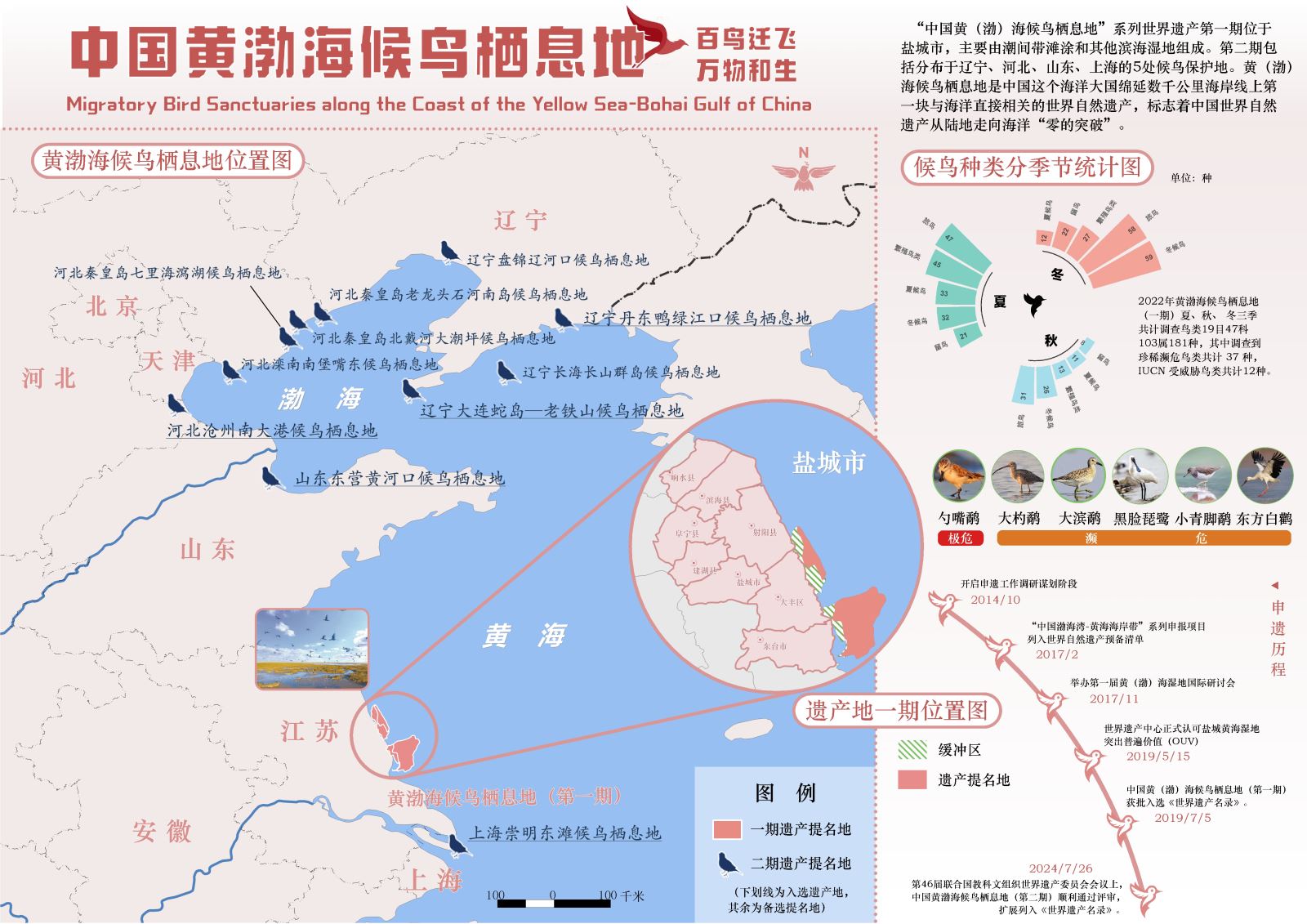
Figure 1: Thematic Map of Migratory Bird Sanctuaries Along the Coast of the Yellow Sea–Bohai Gulf of China
This map presents essential information about the World Natural Heritage site, the Migratory Bird Sanctuaries along the Coast of Yellow Sea–Bohai Gulf of China. The main map uses raster vectorization to delineate the buffer zones and core areas of Phase I of the sanctuaries. In the layout, a circular bar chart illustrates the seasonal distribution of migratory bird species, while images and timelines showcase six rare bird species and the site’s journey to World Heritage inscription. This allows readers to intuitively appreciate the harmonious coexistence of humans and nature in the sanctuaries.
In the companion map, Migration Routes of Birds in the Yellow Sea–Bohai Gulf, the participants mark the flight paths of migratory birds and the sanctuaries, alongside a map of the world's eight major migratory routes. This helps readers understand the critical importance of the Yellow Sea–Bohai Gulf region for bird migration.
They also collected a decade of observational records of the endangered spoon-billed sandpiper in the region and generated corresponding kernel density analysis maps and line charts using software tools.
2.Thematic Map of Badain Jaran Desert—Towers of Sand and Lakes
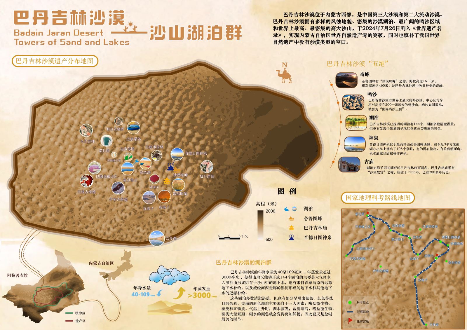
Figure 2: Thematic Map of Badain Jaran Desert—Towers of Sand and Lakes
This map introduces the World Natural Heritage site, Badain Jaran Desert—Towers of Sand and Lakes. The base map is a layered DEM terrain representation of the desert, enhanced with points of interest such as lakes, ancient temples, and sacred springs, accompanied by real-life photographs. The team also included a map of national geographic survey routes and created original illustrations to explain the formation of the desert lakes, integrating scientific education into the map design.
3.Green Breakthrough in the Badain Jaran Desert
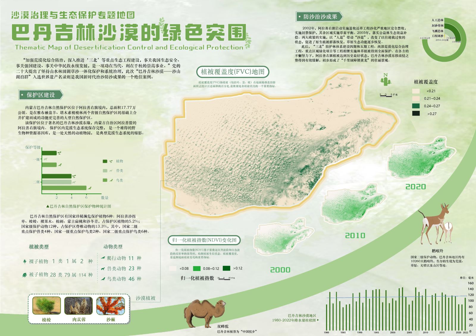
Figure 3: Thematic Map of Desertification Control and Ecological Protection
This map highlights the achievements in desert control and ecological protection in the Badain Jaran Desert. The main map, Vegetation Coverage (FVC) Map of the Badain Jaran Desert, along with three sub-maps showing Normalized Difference Vegetation Index (NDVI) Changes, visually depicts vegetation changes from 2000 to 2020, reflecting the success of China's "Three-North" Shelterbelt Program and desert management efforts. The layout also features bar charts and donut charts statistics on species numbers in the Badain Jaran Nature Reserve, desert control results, and annual precipitation changes, enhancing the map's scientific rigor through data visualization.
4.Beijing Central Axis: A Masterpiece of China’s Ideal Urban Order
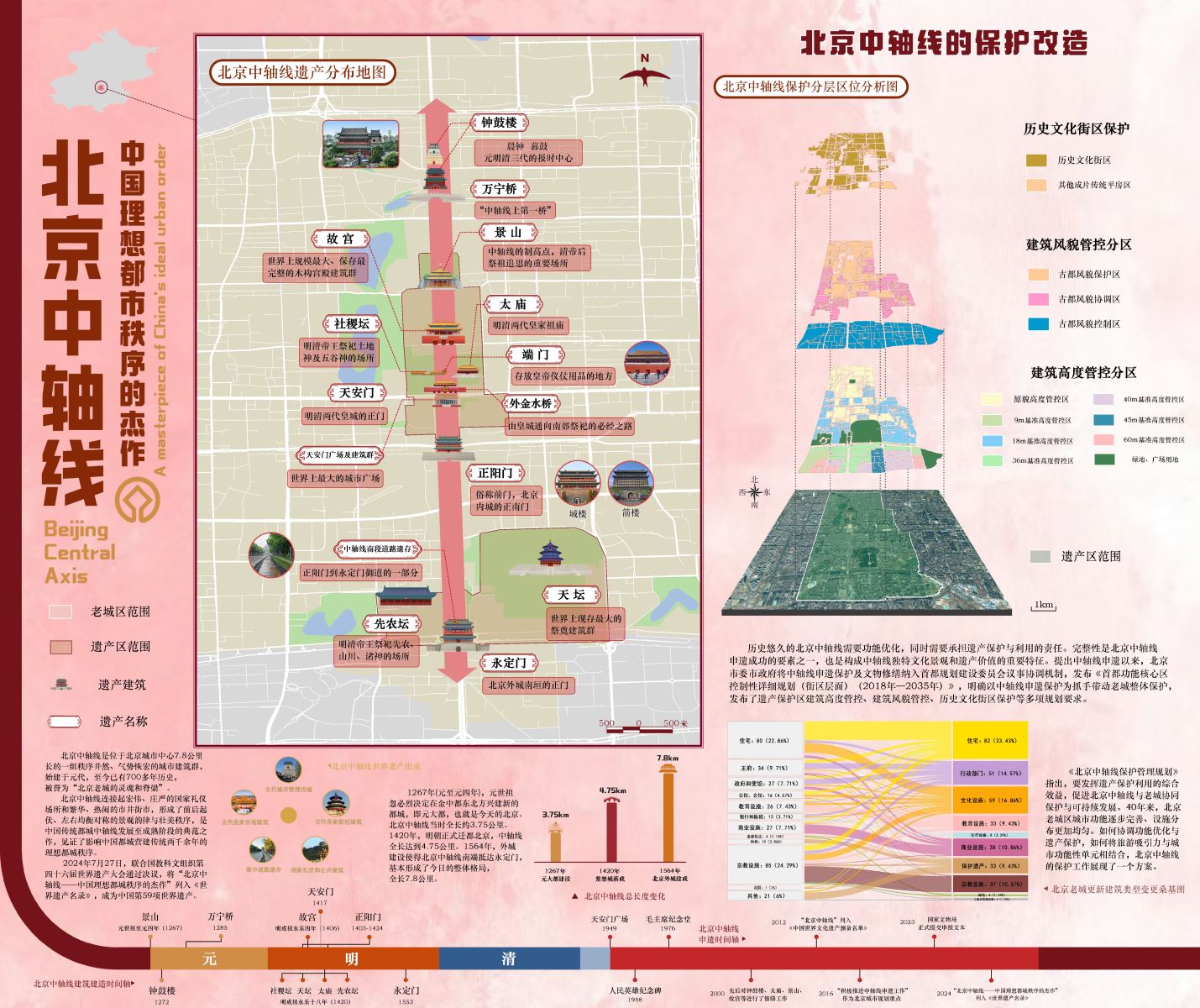
Figure 4: Beijing Central Axis: A Masterpiece of China’s Ideal Urban Order
This map presents the World Cultural Heritage site, the Beijing Central Axis, detailing its fundamental aspects and conservation efforts. In the main map, Distribution Map of Heritage Sites Along the Beijing Central Axis, custom illustrated symbols mark the heritage sites along the axis. For supplementary maps, the team created a three-tiered map showing different protection zones and a layered location analysis diagram using perspective techniques. In the lower right corner of the layout, a Sankey diagram illustrates changes in building types during the renewal of old Beijing, aiding in showcasing the evolution of urban functions over forty years of conservation and transformation along the central axis.
The companion map, Historical Evolution of the Beijing Central Axis, focuses on the axis's millennial historical development, emphasizing cultural continuity. The main map, Modern Beijing Central Axis, highlights contemporary landmarks and new features. Sub-maps respectively display the layout of Beijing during the Yuan, Ming, and Qing dynasties, reflecting the historical evolution of the central axis.
Ⅱ Instructors' Review
This atlas features a novel theme, exquisite production, and outstanding visual effects. The seven maps complement each other, revealing the rich connotations of China's World Heritage sites. The project not only demonstrates the team’s professional competence and innovative thinking but also reflects deep contemplation on cultural heritage conservation. It is particularly commendable that the team produced such a content-rich and beautifully designed atlas without having yet taken courses on Principles of Geographic Information Systems or Cartography in their freshman year!
1.Unique and keeping up on events of the day
The topic closely aligns with current hot topics. The team paid attention to and thoroughly researched the recently held 46th UNESCO World Heritage Committee session, creating works centered on China’s newly inscribed World Heritage sites. The theme is innovative and unconventional.
2.Diverse and scientific data sources
The atlas utilizes a wide range of data, including statistical charts, remote sensing images, and vector map data. The comprehensive use of multiple data types not only enhances the scientific validity and authority of the map content but also improves the visualization of information.
3.Substantial workload and high technical difficulty
The atlas consists of seven maps, involving complex data processing and artistic design. The team had to collect and organize multi-source data while repeatedly optimizing map design and color schemes, fully demonstrating the considerable workload undertaken.
4.Diverse spatial analysis methods with innovative applications:
During the mapping process, the team adeptly employed various spatial analysis methods, such as buffer vector analysis, overlay analysis, and kernel density analysis, and innovatively integrated spatial interpolation techniques. This not only made the map expressions more scientific and rigorous but also enhanced the information capacity and readability of the maps.
5.Clear structure and exquisite layout design:
Led by the Thematic Map of World Heritage Sites in China, the atlas skillfully introduces six subsequent maps detailing the three new World Heritage sites, ensuring logical clarity, coherence, and strong continuity. Meanwhile, the map layout is excellently designed and reasonably arranged, delivering impressive visual effects.
© 1997-2025 SuperMap Software Co., Ltd.
6/F, Building 107, No. A10, Jiuxianqiao North Road, Chaoyang District, Beijing
Links:SuperMap