Seal of East Lake: Experiencing Its Exceptional Charm
l Participating Institution: China University of Geosciences, Wuhan
l Instructors: Yang Nai, Zheng Dandan
l Team Members: Xiao Yining, Liu Wuke, Liu Huimin, Liu Tingting
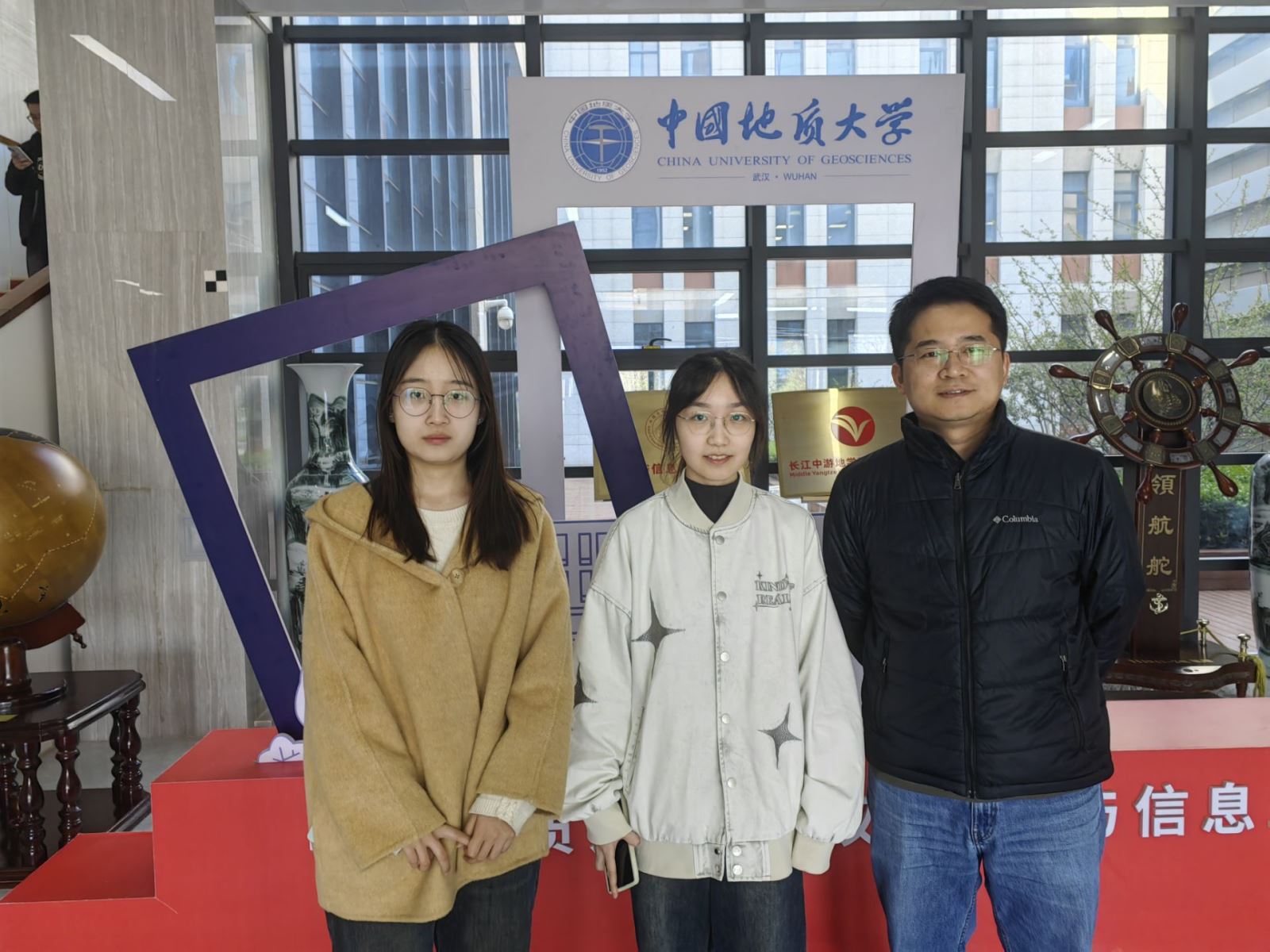
From left: Liu Huimin, Xiao Yining, Instructor Yang Nai
Ⅰ Project Introduction
As a cultural landmark of Wuhan, East Lake boasts unique natural scenery, rich cultural heritage, and profound ecological value. "Seal of East Lake: Experiencing Its Exceptional Charm" not only showcases the natural beauty of East Lake but also promotes and preserves its cultural significance.
Against the backdrop of advancing cultural and tourism integration and the goal of "accelerating the construction of a strong tourism nation," this entry comprehensively introduces the unique charm of East Lake from five perspectives: location overview, East Lake Greenway, dining and accommodation, seasonal scenery, and historical culture. It provides tourists with a detailed travel guide, allowing them to appreciate the natural beauty of East Lake while deeply experiencing its rich historical and cultural heritage, easily finding comfortable dining and lodging options, and fully enjoying leisurely walks along the East Lake Greenway. Each map features a QR code that can be scanned via WeChat to access immersive videos related to the map, offering tourists a more intuitive and vivid way to explore travel information.
Below is a detailed introduction to Wuhan East Lake from five perspectives.
1.Lake Scenery: An Initial Overview of East Lake
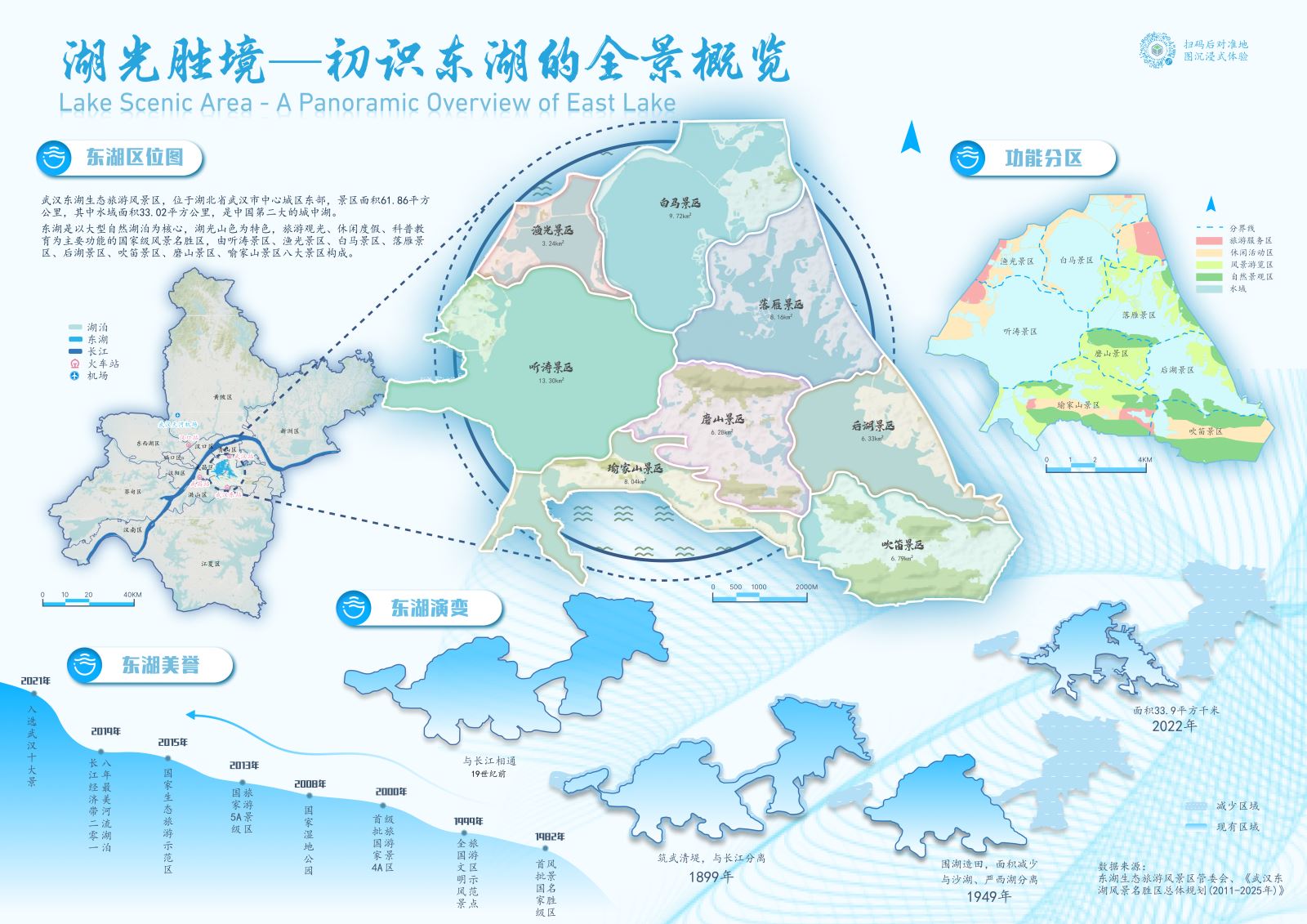
Figure 1: Lake Scenery—An Initial Overview of East Lake
This map comprehensively presents the landscape and changes of East Lake, giving tourists a preliminary impression. Through the main map of East Lake’s divisions and three supplementary maps—Location Map of East Lake, Functional Zoning Map of East Lake, and Evolution Map of East Lake—it displays the geographical location and scope, functional zoning, and historical development of East Lake.
It showcases the eight major scenic areas and functional zones while providing an overview of the lake’s water area. A timeline vividly illustrates the historical changes in the water area of East Lake since the 19th century. A step chart highlights the numerous honors and awards East Lake has received for its unique charm.
2.Greenway Encircled: Exploring the Natural Journey of East Lake
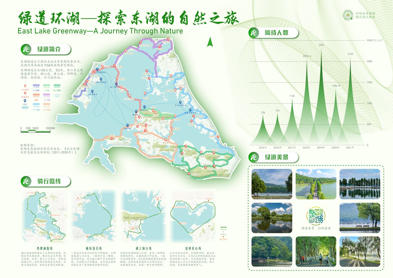
Figure 2: Greenway Encircled—Exploring the Natural Journey of East Lake
This map focuses on the East Lake Greenway, integrating its scenic beauty, surrounding piers, and other information. It showcases the natural landscape and cultural characteristics of the greenway through cycling routes, scenic images, visitor statistics, and more.
The seven greenways are distinguished by different colors, supplemented with symbols marking natural and cultural attractions along the way, providing detailed and intuitive guidance for cyclists and pedestrians. Supplementary maps themed on the greenway introduce featured cycling routes and scenic spots along the way. Embedded QR codes add multimedia elements, enriching the map’s information.
3.Lakeside Feast: Savoring the Local Delicacies of East Lake
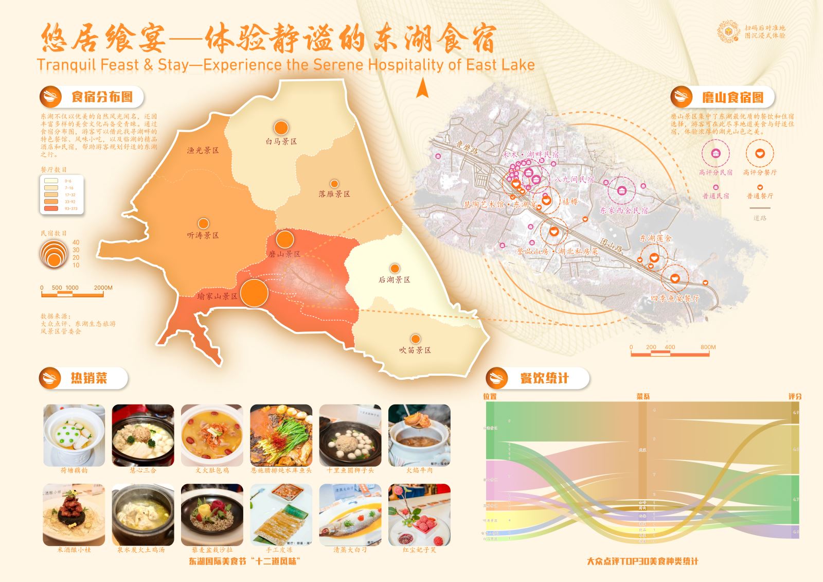
Figure 3: Lakeside Feast—Savoring the Local Delicacies of East Lake
This map addresses dining and accommodation needs for tourists. The main map uses graded statistical and zonal statistical charts to visualize the number of restaurants and homestays in the scenic area. Focusing on the Mo Mountain Scenic Area, which has a high concentration of dining and lodging options, the top 30 restaurants and homestays based on public ratings are distinguished with different symbols and overlaid on processed remote sensing images for practical reference.
Additionally, restaurants are categorized using a Sankey diagram based on scenic area type, cuisine, and ratings, intuitively displaying their popularity. The map also features images of the "12 Must-Try Dishes" from the East Lake International Food Festival, enhancing the visual experience for viewers.
4.Scenery Changes with Seasons: Admiring the Four-Season Views of East Lake
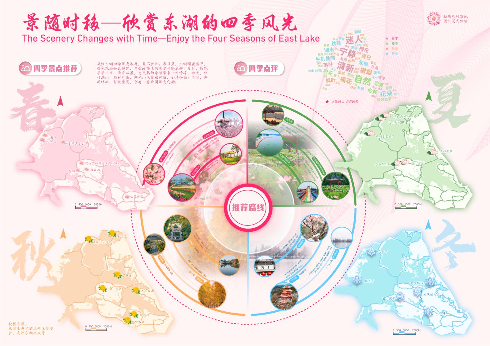
Figure 4: Scenery Changes with Seasons—Admiring the Four-Season Views of East Lake
This map vividly presents the most recommended attractions to visit in spring, summer, autumn, and winter using brilliant colors and lively symbols. The iconic colors of the four seasons and floral symbols—pink cherry blossoms for spring, elegant lotus flowers for summer, bright chrysanthemums for autumn, and pure snowflakes for winter—serve as markers to intuitively display the distribution of attractions.
The design incorporates the concept of a "clock," dividing the dial into four quadrants representing the progression of seasons and the passage of time. Each quadrant details recommended routes for the corresponding season, offering tourists a travel blueprint that transcends time and season.
5.Cultural Flow: Tracing the History and Culture of East Lake
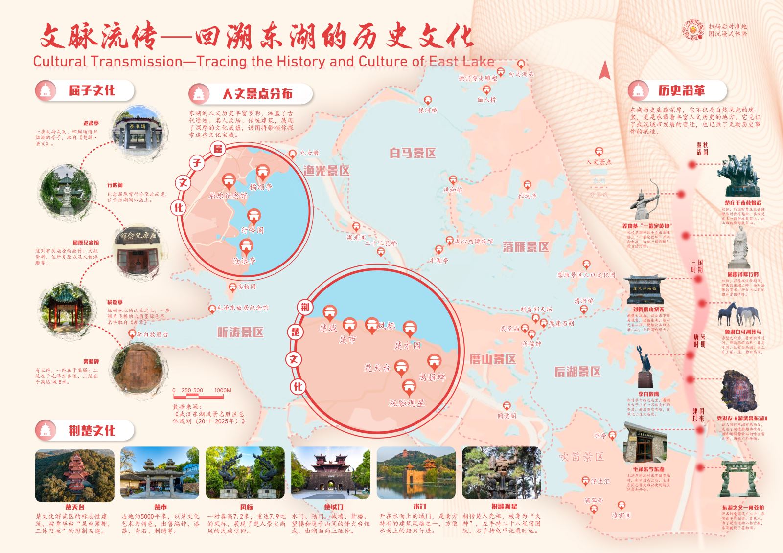
Figure 5: Cultural Flow—Tracing the History and Culture of East Lake
This map focuses on the historical and cultural aspects of East Lake, showcasing its cultural treasures from three perspectives: Quzi culture, Chu culture, and historical evolution. The distribution map of cultural attractions serves as the background, not only as decoration but also carrying important geographical and cultural information. Two sections of the background map are circled and enlarged to detail the long history and brilliant culture of the Quzi culture and Chu culture sections.
Representative and narrative images introduce each attraction, allowing users to clearly see the specific locations and distribution of related sites. East Lake has witnessed and recorded historical changes from the Spring and Autumn and Warring States periods to the Tang and Song dynasties, and even to the founding of the nation. A vertical timeline clarifies the historical context, enabling users to feel the pulse of the times.
Ⅱ Instructors’ Review
This project integrates multi-source heterogeneous data, including DEM data, administrative division data, remote sensing image data, and crawled new media data. After scientific processing, it comprehensively showcases the unique charm of East Lake through five thematic maps covering overview, greenway, dining, scenery, and historical culture.
Each map in the project has a distinct theme and trendy design, brilliantly presenting visual content through various expression methods such as 2D, 3D, lighting effects, charts, and images. Additionally, the project seamlessly integrates dynamic visualization methods like virtual reality and videos into originally static map designs via QR codes.
The color design of the maps is particularly meticulous and creative. Every map in this project is carefully polished and excels in all aspects.
© 1997-2025 SuperMap Software Co., Ltd.
6/F, Building 107, No. A10, Jiuxianqiao North Road, Chaoyang District, Beijing
Links:SuperMap