Zhitong Luojia — Wuhan University Smart Campus System
Participating School: Wuhan University
Advisors: Pan Jun, Chen Yumin
Team Members: Shi Yutao, Su Feiya, Yang Jun, Liu Licheng

Group Photo (from left): Shi Yutao, Liu Licheng, Su Feiya
ⅠProject Introduction
System Background
In recent years, with the rapid development of higher education in China, university campuses have continuously expanded, the number of buildings and public facilities has increased significantly, and the spatial distribution relationships of various surface features on campus have become increasingly complex.
Traditional printed maps, due to their long update cycles, single functionality, and limited information presentation formats, struggle to meet the operational needs of university administrators for real-time campus data updates.
They also fail to provide convenient query services for buildings, facilities, roads, and other information for teachers, students, and visitors.
Against this backdrop, smart campus construction has become an important direction for improving campus management efficiency and service levels. Building efficient and convenient campus management systems through digital and intelligent technological means has become an inevitable trend in the modernization of universities.
Therefore, this team, using Wuhan University as a case study, developed the "Zhitong Luojia—Wuhan University Smart Campus System." It aims to address pain points in campus management through information technology, enhance campus operational efficiency, and optimize the service experience for teachers, students, and visitors.
Data Production and Processing
The development team collected relevant 2D and 3D data themselves. Using SuperMap iDesktop 11i as the data processing and production tool, they completed the following tasks:
System Module Design and Technical Approach
The system uses SuperMap iServer as the core GIS server for storing data and publishing services. 2D and 3D GIS function development is based on SuperMap iClient JavaScript for Leaflet.
.png)
Figure 1 System Architecture Diagram
System Function Demonstration
1. Map Browsing
Users can click the "2D Map" or "3D Map" buttons under the top menu item "Switch Map" to toggle between the 2D map and 3D map views.

Figure 2 2D Map Display

Figure 3 3D Map Display
2. Data Query
Users can utilize the "Query Buildings by Category" function or the search box for "Specific Building Query" to search for campus buildings or attractions. This function supports both 2D and 3D modes.

Figure 4 Data Query Diagram
3. Route Planning and Navigation
Users can enter the destination name in the navigation search box, set the destination, and choose a transportation mode based on Wuhan University's characteristics: "Bike Sharing," "Campus Bus," or "Walking." Clicking the "Navigate" button displays the planned travel route on the map.
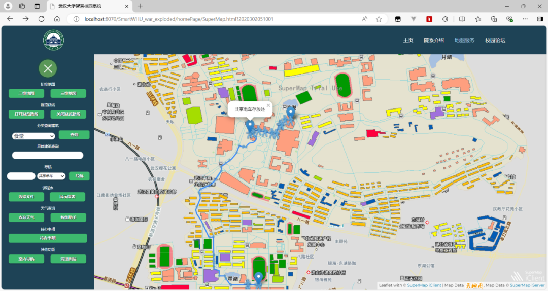
Figure 5 Route Planning Diagram
4. Recommended Tour Route
As Wuhan University is known as "the most beautiful university in China," we have set up a tour route covering its popular attractions. Users simply click the "Open Tour Route" button in the menu to see the location, images, videos, and descriptions of each attraction on the route displayed on the map. Scrolling the mouse wheel allows browsing other attractions, and the map will jump to the currently viewed attraction's location as the content on the right changes. This function supports both 2D and 3D modes.
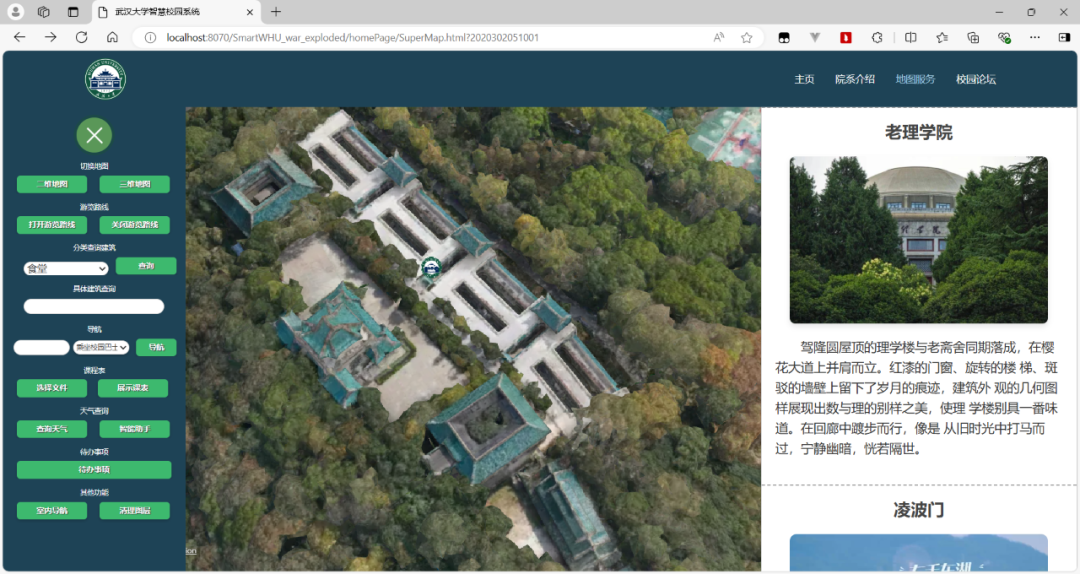
Figure 6 Tour Route Diagram
5. Schedule Management Function
Users can input to-do items into the system calendar for daily study and work management.

Figure 7 Schedule Management Diagram
Clicking the "Show Day Schedule" button below the calendar marks the locations involved in the schedule for the selected date in sequence on the map and displays the routes between them. Users can visually see their daily schedule and routes. This function supports both 2D and 3D modes.
Figure 8 Itinerary Route Diagram
Clicking the "Navigate" button below the calendar causes the system to display the destination of the user's nearest upcoming task based on the current time and their to-do items, along with the route to get there.
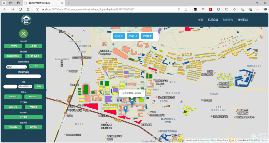
Figure 9 To-do Navigation Diagram
Clicking the "Schedule Analysis" button below the calendar allows users to view charts generated based on the schedule for the currently selected month, analyzing their frequently visited places and common tasks, facilitating personal time management and planning.

Figure 10 Schedule Analysis Diagram
The system supports importing personal class schedules, convenient for student users.
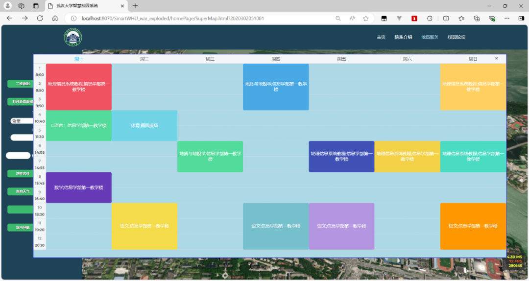
Figure 11 Personal Class Schedule Diagram
6. Smart Assistant Function
The system integrates an AI assistant, supporting both voice and keyboard input. Users can use this smart assistant for building queries, route queries, etc., to conveniently and quickly meet their needs. They can also chat with it and query knowledge.

Figure 12 Smart Assistant Function Demonstration
7. Weather Query
Clicking the "Query Weather" button in the menu displays charts at the bottom of the page showing the campus's forecasted high temperatures, low temperatures, and weather conditions for the next week, helping users plan their trips.

Figure 13 Weather Query Function Demonstration
8. Campus Forum Function
This section integrates functions such as notice display, a "Second-hand Market," "Topic Comments," and related features.
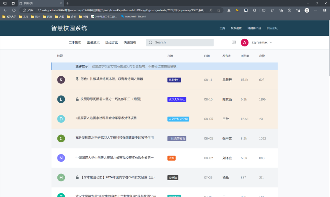
Figure 14 Campus Forum Function Demonstration
System Highlights
Ⅱ Team Summary
This project started from the perspective of actual needs, independently acquired data, utilized relevant GIS development technologies, and combined them with artificial intelligence to design a fully functional, high-performance WebGIS system with considerable practical value and reference significance.
Finally, we thank all team members for their hard work and the advisors for their patient guidance. We wish everyone a bright future and great success. We also hope every participant seeking inspiration from our project review achieves satisfying results!
Ⅲ Advisor's Review
This project revolves around the officially designated theme of "Smart Campus," using Wuhan University as an example. Starting from the user's perspective, the team independently collected relevant 2D and 3D data, used SuperMap GIS software to complete spatial data processing, cartography, and system development, resulting in this feature-rich and distinctive smart campus platform. It effectively demonstrates the application of GIS data and technology in daily life and provides a reference for smart campus management.
© 1997-2025 SuperMap Software Co., Ltd.
6/F, Building 107, No. A10, Jiuxianqiao North Road, Chaoyang District, Beijing
Links:SuperMap