Published:2019.04.08
Title: Campus Fire Safety Assistant System Based on GIS+BIM (Excerpt)
University: North China University of Technology
Instructors: Liu Yajing and Ren Yongqiang
Team leader: Zhu Bangren
Team members: Yang Xiao, Wen Danqi and Yue Chao
With the continuous expansion of the scale of higher education in China, colleges and universities generally take the construction of high-rise buildings to improve the per capita area, but the fire hazards caused by high-rise buildings are far more complex than low-rise buildings. The relationship between building floor height and fire risk does not increase in a fixed proportion, but in an exponential way. The fire rescue work of high-rise buildings is more complex, so the fire risk assessment and emergency rescue norms of high-rise student apartments require more.
The campus fire safety assistant system based on GIS+BIM adopts C# language under Microsoft Visual Studio platform, and combines SuperMap for JavaScript and WebGL of SuperMap GIS 9D series products for secondary development. The work uses Microsoft SQL Server as the core database, through the analysis and design of fire safety in Colleges and universities, and combined with the abundant data resources of the campus to build a campus safety assistant system. The system standardizes the maintenance process of firefighting equipment in schools, including the repair part of students and the maintenance part of maintenance personnel. By analyzing various weight factors, the system realizes the maintenance of firefighting equipment in schools. At the same time, through the particle effect of WebGL, the fire scene is simulated. SuperMap GIS 9D series products are imported into BIM fine model to simulate indoor fire scene, which provides three-dimensional route planning for fire trucks.
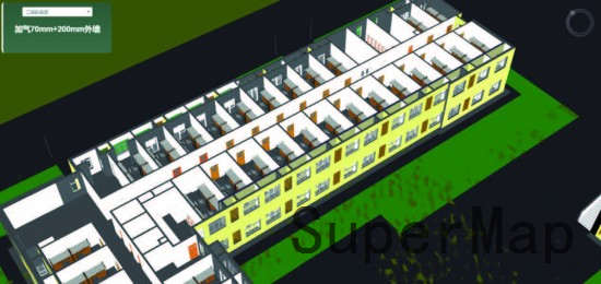
1. Through SuperMap GIS 9D series products, the BIM model data sets are lightweight processed to provide a smoother three-dimensional visualization effect. The building model display function from outside to inside is applied to the campus fire safety assistance, which makes the fire rescue efficient, safe and integrated. Rescue workers can make a detailed analysis of the firefighting facilities, safety passages and the internal structure of dormitories in order to achieve the best rescue.
2. The traditional two-dimensional shortest path analysis is extended to three-dimensional visualization, which solves the unreasonable situation of path planning caused by the large area of campus and the dense vertical and horizontal road network. At the same time, the firefighting equipment and its status in the whole school are displayed in three-dimensional form, so as to facilitate the fire fighters to select appropriate firefighting equipment.
3. Real-time monitoring of the temperature inside the building avoids the lack of information on the fire inside the building caused by the smoke generated by the fire. At the same time, the indoor monitoring equipment can be used to avoid the false alarm situation caused by the damage of the fire alarm.
4. Based on the actual situation of the students' apartments in our school, five first-level fire risk assessment indicators and 18 second-level fire risk assessment indicators are summarized from five aspects: the fire prevention ability of the dormitories themselves, the safety evacuation of personnel, fire emergency rescue, external fire hazards and the level of fire safety management. A hierarchical fire risk assessment index system for high-rise students' apartments is established.
1. Management of firefighting equipment in school: administrators can inquire the firefighting equipment in school according to their needs, and check the status of the equipment. Red represents the current state of inability to use, green represents the normal state of use.
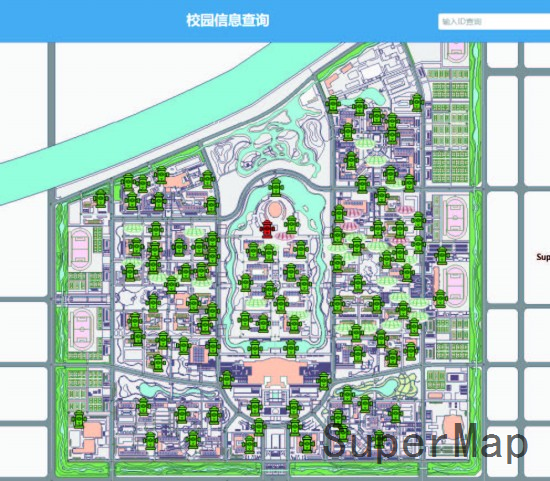
Distribution of Fire Fighting Equipment in School
2. Fire monitoring: After a fire disaster occurs, the sensor can be located at the fire source, and the temperature changes around the sensor can be monitored and displayed in the form of a broken line chart. At the same time, the monitoring equipment inside the building can be invoked to view the internal details.
3. Three-dimensional attribute query and roaming: Because the visualization degree of two-dimensional map is relatively low, and the detailed information inside the building cannot be displayed, the BIM model can be imported through SuperMap GIS 9D platform and processed lightly, which can realize indoor roaming and layered profile query of building material information.
4. Campus three-dimensional display and rescue route planning: displaying the distribution and status information of campus fire-fighting equipment through three-dimensional model, and planning the campus fire-fighting rescue route at the same time.
Hierarchical Query for Attribute Information
The whole system mainly serves administrators, students and maintainers. It has rich functions and is practical and efficient. It includes perfecting the maintenance system of school firefighting equipment; three-dimensional simulation demonstration of fire scene; three-dimensional roaming rescue route for rescue firefighters; and three-dimensional safety evacuation plan demonstration for students. The project effectively realizes the two-dimensional and three-dimensional integrated management of campus fire spatial information.
The work combines with the current popular intelligent city architecture of GIS+BIM and realizes the system function with B/S architecture supported by SuperMap GIS 9D platform. The work provides powerful support technology for fire rescue. It visually displays the periphery and interior structure of each building with three-dimensional entity model, and can view the basic information and interior structure of each building. Fireproof material. The whole system has an attractive and generous interface and is a complete and systematic entry.
The work uses BIM+GIS technology, the three-dimensional effect is relatively smooth and dazzling. Data lightweight is good, but BIM data volume is generally larger, after the scope of application increases, we need pay attention to the problem of data lightweight. It is suggested to focus on only one target user, and then solve all his points. The target user can be an administrator, who can publish content. Besides, function to send escape routes to mobile phones near dangerous buildings can be added.
© 1997-2020 SuperMap Software Co., Ltd.
6/F, Building 107, No. A10, Jiuxianqiao North Road, Chaoyang District, Beijing
Links:SuperMap